 Two weeks ago, we looked at the old Washington Canal and its short and unhappy life, by the end of which it was an open sewer. Today, we will look at its life after death, how the land on which it was originally built was used since.
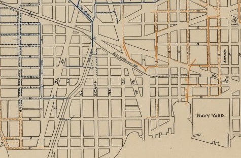
Given the canal’s use in 1868, it was suggested that it should simply be covered over and turned into an underground sewer. A map from 1880 showing the sewer system of DC leaves no doubt that this suggestion was followed – up to a point. Under Constitution Avenue, and in front of the Capitol, there is indeed a fine brick sewer. Further in southeast, however, the sewer no longer follows the old canal, and in fact peters out well before reaching the Anacostia. The reason for this is simple: The area formerly used by the canal now contains the newest form of transportation, the railroad. It is, in fact, the Baltimore and Potomac Railroad, which led to the railway station in the middle of the Mall (the same where President Garfield was shot, but that’s a very different story)
The only part of the canal still existing was a short stub leading up Second Street and New Jersey Avenue, and a 1903 map shows even this filled in and the whole area empty. Right next door was the wharf of the American Ice company, as well as a number of lumber yards. In 1905 the empty space was turned into something much more useful to DC: A sewage treatment plant. This is the remarkably ornate building just to the west of Yards Park and visible from there. It remains in operation as WASA’s Main Pumping Station. While the treatment plant was being built, the small stub of the canal was added in again, and it remains until today.
Further north, the land was used for industrial buildings, and later a school bus parking lot. It is this part that is being turned into Canal Park today. For more information on this, see this post at the From Carrollsburg To Capitol Riverfront blog. (As a special bonus, it also includes a scan of a lottery ticket from the original lottery to build the canal.)
As far as the rest of the land used by the canal, particularly the leg leading towards South Capitol Street the decline of the railroads through the 20th century set that free again, and it is today used by the SE-SW freeway.
In short, the land originally set aside to ease the passage of goods and people through the capital is still used as such. Except at rush hour, of course.


I wonder if there is any way to restore portions of the canal, as the Los Angeles River has been restored there?
Probably not. I’m not as familiar with LA, but Providence, RI uncovered their river as well to great success as well recently. Unlike these examples though, the canal was not a natural feature and doesn’t have a flow of water into the river. As such, it would just be a stagnant body of water, which is why it was covered in the first place.